The lane was used as early as the Middle Ages for transporting grain and connected the hamlets of Pinner and Roxeth. With its fertile soil and strategic location, it attracted farmers and settlers seeking to cultivate crops and rear livestock.
In medieval times the major part of a settlement’s agricultural land, called common fields, was normally shared by all its villagers. Each family would have several plots, scattered among these fields. Every few years the plots each family farmed were changed around so as to share the good and bad land. It appears this practice ceased in Harrow by the eighteenth century.
In Pinner the plots of common agricultural land had been grouped into three fields, Longfield, Middlefield and Downfield. Two short pathways for access to the plots separated these fields, approximately along the lines of the present day Cannon Lane and Rayners Lane.
The lane was originally called Bourne Lane because it crossed several streams, including Yeading Brook. It was also known as Lanketts Lane, Lankers Lane or Yeading Lane.
The system of farming in Pinner changed radically at the start of the 19th century. Enclosure meant that common land, previously used by all of the community, was enclosed and sold to local landowners. It was a very complicated affair which took about twelve years to complete. New farms were established such as Daniel Hill’s Farm which had many fields either side of the Lane. However, Daniel Hill actually lived at Church Farm near St John’s Church in the centre of Pinner.
The area remained predominantly rural until the 19th century when rapid urbanisation began to take hold.
During the 1820s or 1830s Daniel Hill built accommodation for his labourers, a cottage with animal and cart sheds, where Farm Avenue now meets Rayners Lane. George Rayner and his family moved into these buildings in 1841.
In the 1851 Census Daniel Rayner is living in “Mr Hill’s Farm in the road to Roxeth”.
In a conveyance dated 4.10.1856, two fields on the west side of what later became Rayners Lane, stretching from the present Greenway to Village Way, were called Upper Rayners Field and Lower Rayners Field. These are the first official documented use of ‘Rayners Lane’. It is assumed the informal adoption of Rayners Lane to denote the lane was sometime before the Rayner family left the area in the 1870s. However, the lane itself is nameless on the 1896 OS map.
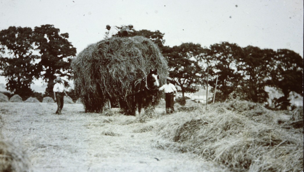
By 1865 horse powered threshing machines had been installed at the buildings in Rayners Lane, but hay farming was still dominant. The fields provided hay for the London markets and grazing for tired London horses.
Later residents of the cottages are hard to confirm but might have been Henry Deacon, agricultural labourer, in 1881 and very probably William Lavender, a gamekeeper, in 1891.
The Rayner’s cottage was the only building in the whole of what is now Rayners Lane before the isolation hospital was built near the southern end to towards the end of the century.
The Arrival of the Railway
The pivotal moment in Rayners Lane’s history came with the arrival of the railway. The Metropolitan Railway, later to become part of the London Underground’s Metropolitan line, extended its tracks through Pinner during the latter half of the 19th century, connecting the area to central London and facilitating easier transportation of goods and people. This newfound accessibility sparked a surge in development, transforming the whole area into a thriving residential and commercial hub.
However it was not until 1904 that a local station called Rayners Lane Halt was opened (Halt stations are very basic, small railway stops, often in rural areas, with minimal facilities like a simple platform and sign, where trains often only stop on request). The naming of this station likely incidentally consolidated the place name of Rayners Lane.
In the early 1920s there were still only two houses on Rayners Lane. The family of Daniel Hill no longer lived locally and therefore built a farmhouse for their new farm manager, Henry Smith, and so the present no. 552 Rayners Lane was built about 1915 to serve this purpose. It was called variously Lankers Brook Farm or Brook Farm and is now probably the oldest building along the whole length of Rayners Lane.
Later in the 1920s, the land owned by Daniel Hill, including the “Rayners Fields”, was sold to the Metropolitan Railway, setting the stage for housing development in the 1930s.
The Rise of Metroland
Metroland is the name given to these housing developments that stretched out of London to the counties of Buckinghamshire, Hertfordshire and Middlesex, that were served by the Metropolitan Railway. (The name Metroland was coined by the Met’s marketing department in 1915 and used to heavily promote the new developments).

